FieldGenius
FieldGenius Banner!
FieldGenius Software: Smarter Surveys Start Here
Discounts on STAR*NET, MicroSurvey CAD and FieldGenius + MicroSurvey CAD Bundle
for 50% off new licenses of MicroSurvey


Available for both Android and Windows, FieldGenius supports a wide range of hardware and offers flexible licensing at a price that fits your budget.

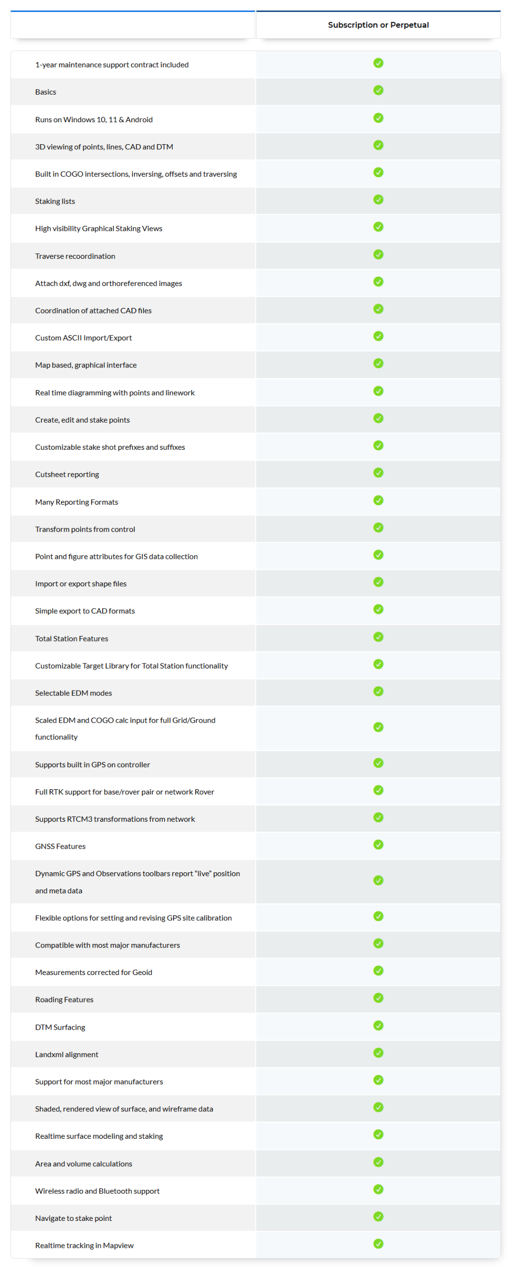
Core Field Surveying Tools and Capabilities in FieldGenius
Key features include:
- Real-time GNSS and total station support for high-accuracy data collection
- Automated linework generation with support for smart, code-free drawing
- Advanced stakeout tools for points, lines, and surfaces
- Built-in COGO tools to solve traverses, intersections, and calculations in the field
- Field-to-finish compatibility for quick export in DXF, CSV, LandXML, and more
- Intuitive, map-based interface with live updates and in-field editing
- Custom code libraries that maintain consistent symbology across all survey projects
Click for Feature List
How Does FieldGenius Software Work?
- Launch the software on Windows or Android-based devices
- Connect instantly with supported GNSS receivers or total stations
- Collect points, stakeout lines, surfaces, and features with precision
- Draw linework live in the field and automate feature coding
- Export clean data in CAD-friendly formats like DXF, DWG, CSV, or LandXML
- Integrate effortlessly with AutoCAD, MicroSurvey CAD, or GIS software for post-processing
Designed to handle tough conditions and complex workflows, FieldGenius doesn’t just keep up—it leads the way!
Why FieldGenius is Perfect for Surveyors and on Construction Projects
Surveyors and construction professionals rely on accurate, real-time field data. FieldGenius data collection software is engineered to handle infrastructure and site layout and land development tasks with ease.
Precise Stakeout Tools
Field crews can lay out points, lines, alignments and surfaces with pinpoint accuracy, minimizing rework and increasing productivity on site.
Seamless Integration
Compatible with leading GNSS receivers, robotic total stations and Android- or Windows-based data collectors, FieldGenius adapts to the tools you already use.
Map-Based Interface
Its interactive user interface lets surveyors see and edit data directly in the field, ensuring clarity and confidence at every step.
Field-to-Finish Compatibility
FieldGenius survey data export options include DXF, CSV, LandXML and other CAD-friendly formats, reducing office processing time.
Supports Road and Alignment Data
Easily manage corridors, centerlines and profiles for road construction and site design.
Offline Capability
FieldGenius can function entirely offline, allowing surveying and GNSS data collection even in the most remote areas with no internet access.
Why Call Complete CAD Solutions for your FieldGenius software?
Why Choose Us?
- Authorized Dealer & Trusted Partner
- Competitive pricing with included training
- Hassle-Free purchases, upgrades & renewals
- CAD Starter Review – to guide your first purchase
- CAD Utilization Review – track, trim, tune your setup
- Support built for land development professionals
Every Purchase of Software Includes:
- Fast license provisioning and setup help
- Technical support from us and from That CAD Girl
- 12-month Webinar Series subscription
- Virtual Classroom registration
- 24/7 access to your secure customer portal
Why Choose FieldGenius from Complete CAD Solutions?
Frequently Asked Questions (FAQs)
What is FieldGenius used for?
FieldGenius is data collection software used for land surveying, construction layout and topographic mapping in land developments. It helps professionals collect, visualize and export accurate field data quickly and efficiently.
What devices are compatible with FieldGenius?
FieldGenius for Windows supports a wide range of total stations and GNSS receivers. FieldGenius for Android is available on rugged tablets and mobile devices and supports many leading GNSS brands. Always refer to the FieldGenius supported hardware list to confirm compatibility.
Can FieldGenius work offline in remote areas?
Yes, FieldGenius is fully functional without an internet connection. It’s designed for remote, off-grid surveying and stores all project data locally on the device for later syncing or export.
Does FieldGenius support CAD file formats?
Yes, FieldGenius supports CAD-compatible export formats including DXF, DWG and LandXML. This allows seamless integration with civil CAD survey tools, AutoCAD, MicroSurvey CAD and GIS systems.